Frheete
Societal ties: Balhe
Current population: 1
Main language(s): Nulim
Area: 117,000km²
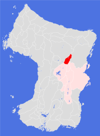
Natural and political borders
The Land is surrounded by mountains ranges to the east and west: Zoiznuu Kandan; Soufwhuum Frhitizhuum; and Zoiznuu Eda'hizhuu. The southernmost point of the Land is marked by the Exile's Rock in the Nuulimuu river at latitude 23.4°N.
History
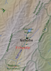
Our sole source of detailed information on this Land has come from an expedition to the valley carried out by Ambostak scientists in gt1189-1192, who were exploring the southernmost reaches of the Abrhuu river when they stumbled across Cebrhuu Nishon and made contact with the people living there.
From the information they gathered, it appears that the valley is a place of exile for those people who fall foul of the Jaesconesh authorities in the Land of Nuulime. Exile appears to be permanent, and men are routinely sterilised before being sent into exile. Even so, the researchers discovered a breeding population in the plantation, and these people - possibly born of women exiled soon after becoming pregnant - appear to control the plantation and the 'city'. The current leader claimed to be able to trace his family back seven generations, which suggests that people were being exiled to this valley in the gt960s (assuming 20 orbits per generation).
Politics and economy
The exile society appears to be feudal in nature, with fertile men in control. Women appear to be considered as property of the fertile men, while infertile men are treated as slaves. Most of the cultivation work is carried out by slave labour, with slaves allowed to keep excess produce - effectively a subsistence economy.
Culture and other issues of interest
Debate continues as to whether further expeditions should be made to the Land, and what help - if any - should be offered to those people who appear to be enslaved. There is a growing belief, particularly within the Balhe Society, that action should be taken against the Jaesconesh in Nuulime for this apparent crime against humanity.
Key natural features
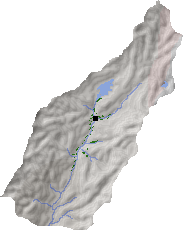
The Land encompasses the northernmost reaches of the Froshmuu Nuulimizhuu, a most unwelcome environment. The main water supply appears to be Cebrhuu Nishon, as little rain falls in these mountains. Key mountain peaks include Mts. Kanduu (6,140m), Nishuu (5,860m), Frhituu (4,920m - an active volcano), Edanisuu (3,660m) and Edajarhuu (4,350m).
Habitats
Most of the Land comprises a north central mountains habitat; the southernmost part of the valley belongs to the central lakelands habitat, but appears to be uninhabited.
Plantations and settlements
Arial photographs of the Land show that there is one large plantation along the upper reaches of the Nulimuu river, extending northwards to Cebrhuu Nishon. The plantation is poorly terraced, and a fair proportion appears to be unkempt or abandoned.
Key towns and cities
Rural population: 0 (0.0% of total)