Aelhpaase
Societal ties: Bartak
Current population: 1
Main language(s): Varam Bathtel
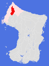
Area: 227,000km²
Natural and political borders
North - Soivjarhuu Paasizhuu; West - Soufsuuftuu Paasizhuu, Soufwhuu Jaenizhuu; South - Zoiznuu Pintolhuu; East - Zoiznuu Bathtelizhuu.
Two political borders have been agreed: with Koletane, all land that falls within the Gonanuu river system west of a point at longitude 160.3°E belongs to Aelhpaase; and with Pintole, all land "within a day's hike of the Pazile-Bazole trail south of latitude 40.8°N" belongs to Pintole.
History
The Tentole Plantation was part of the second stage of the planned expansion to accommodate refugees from the Tells region in Cheidrah. The initial work was undertaken by pioneers from Dashelone Plantation during the gt550s, though work was slow as cultivation techniques had to be adapted to the Northern Valleys habitat. The settlement finally opened to new settlers in gt568, by which time work had already started on establishing new settlements in the Nausuu Gonan. Attempts to colonise the upper reaches of the Gonanuu River began in the late gt690s, and Pazile settlement was finally established in gt708. Since that time there has been no significant cultivation beyond extending the borders of these settlements.
Tentole plantation, together with its sattelite settlements, joined the Bartikol League on its inception in gt720. Pazile Plantation joined the League independently in gt740, Together, the two plantations formed the new Land of Aelhpaase as part of the New Agreement in gt751.
For the next century little happened in the Land, except for a slow growth in population. The Land remained a parochial backwater, playing only a minor role in Bartak politics, until a decision was made to search out a new trade route between Aelhpaase and Omne Land in the gt860s - the Ehkhuu-Agentuu trail was first opened for use in gt867. The new route re-invigorated the Tentole local economy, and led to the search for new routes across the mountains to Damose (the Emprhekuu-Gonanuu trail opened in gt875) and south to the Pentuuk Lands.
The early tenth century saw a rise in the level of banditry on the new trails - particularly the southern trails - which eventually led to the establishment of an Aelhpaase Land Army in gt919. This in turn led to a political reorganisation within the Land, establishing a common set of laws between the plantations and settlements and a new National Parliament, which sat for the first time in gt926.
Politics and economy
The Land of Aelhpaase is effectively a nation state, with a democratically elected central government, a single army, a single body of basic laws and a single currency - the Aelhpaase Credit. Within these structures, each plantation and settlement has some leeway to determine their own local laws, though the governing mechanism for each is centrally determined.
Agruculture remains the mainstay of the economy - the Land is mostly self-sustaining, with relatively productive cultivations. Some light manufacturing occurs in the cities, though this is hampered by the lack of locally produced raw materials. A second source of income is the import and transit levies placed on goods moved across the Land's borders, though these are generally set low to encourage trade.
Culture and other issues of interest
Organised religion is central to many of the Land's inhabitants, with a preference given to the worship of the Earth Goddess.
The banditry of the early gt900s has affected many levels of today's culture. Ballads celebrating the exploits of some of the more renowned (or feared) bandit leaders remain popular, and has given rise to a particular form of music and dance unique to the Land.
Key natural features
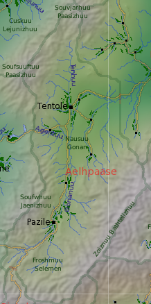
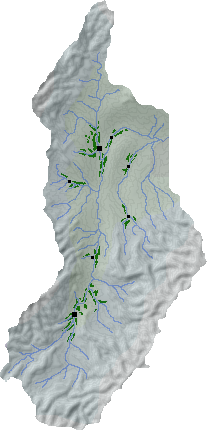
The Land encompasses the entire upper reaches of the Gonanuu River system, with the main valleys surrounded by mountain ranges to the north, west and south. In the north, the Nausuu Tenhon runs south from Souvjarhuu Paasizhuu for some 240km before joining with the Nausuu Gonan. Downstream from Tentole the river runs north and east towards the coast; upstream the valley stretches south some 400km to Pazile. Beyond that city the river forks within the Froshmuu Selemen to the foothills of Zoiznuu Pintolhuu. The lowest part of Nausuu Gonanuu is some 220m above sea level, while the highest mountain (in the northern part of Zoiznuu Bathtelizhuu) is around 5,640m high.
Habitats
The Nausuu Gonan and Nausuu Tenhon are part of the Northern Valleys habitat: all cultivated land within Aelhpaase falls within this habitat. Surrounding the valleys, and making up over half of the total land area, is Northern Scrubland.
Plantations and settlements
Tentole plantation is the largest cultivation in the Land, stretching some 140km by 80km along the Gonanuu and Tenhuu rivers and their tributaries. The plantation is heavily terraced, and hosts one further settlement in addition to the city. Three other settlements have been established within 120km of the city. Pazile plantation lies some 400km south of Tentole, and extends some 120km along the Gonanuu river. Two other plantations lie midway between the two cities, on separate rivers.
Key towns and cities
Rural population: 0 (0.0% of total)