Kaliedan planetology
Planetary statistics
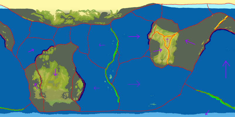
Kalieda's surface is 87.4% ocean and 11.5% land (the remaining 1.7% is the northern ice cap), divided into three key landmasses: Falah, at 29.5 million Km² the largest landmass on the planet; Ewlah (20 million Km²); and Cheidrah, which has 8 million Km² of land free of ice. Two sets of long archipelagos between the continental masses total just under 0.5 million Km² of land.
The planet itself posesses a solid-within-a-liquid iron core, surrounded by a thick stone mantle. At the surface of the mantle the crust is broken into a number of tectonic plates (which are sluggishly mobile), as shown on the map below. The continental plates are less dense than the oceanic plates, which subduct under them and cause much of the planet's volcanic activity. The north pole lies on a continental plate which used to be covered by shallow water. It is believed that the new ice cap has now grown to such a depth that it has grounded itself on the ocean floor. The south pole, by contrast, lies over a deep oceanic plate.
Planetary winds
With almost 90% of the planet's surface being water, Kalieda's climate is dominated by girdles of trade winds which blow constantly, and by cyclonic activity generating powerful typhoons and tropical storms. Most winds are wet winds, and much of the planet experiences a lot of rain. The major wind systems are to a large extent mirrored in the northern and southern hemispheres.
The winds are driven by low pressure generated around the equator by heating of the air and water, which draws in Easterly trade winds from 30°N and 30°S towards the equator.
High pressure cells form at around the 30° N and S latitudes, which push winds both towards the equator and towards the poles. The winds blowing between the latitudes of 30° and 60° N and S are known as Westerly trade winds.
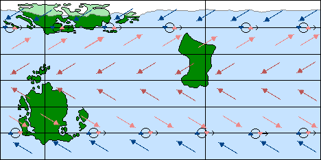
Other high pressure cells of very cold air habitually form over the polar regions, pushing cold air towards the equator. These easterly polar winds meet warmer air at around the 60° N and S lattitudes, where they generate vast cyclonic storms centred around low pressure pockets which move around the planet from west to east.
Finally, tropical storms are generated regularly by osscilations in the equitorial low pressure Doldrums. When a pocket of low pressure gains a spin momentum, a tropical storm builds around it and is fed by the warm ocean waters. A tropical storm will break down and dissipate when it moves over cooler ocean water, or when it hits land, but some storms will continue to circulate around the planet for a considerable length of time, becoming extremely violent and lasting for many weeks.
Oceanic currents
Ocean currents also play an important role in Kalieda's climate. Firstly, there is relatively little mixing between the waters of the northern and southern hemisphere.
In the north, there are two main currents: the northern equatorial shallow and deep currents (the former moving east to west above the latter which flows in the opposite direction), and the northern temparate, a circumpolar current which flows west to east. Some mixing occurs between the cold temparate current and the warmer northern equatorial shallow current, allowing an exchange of heat. The cold, nutrient rich waters of the northern equatorial deep current rise to the surface off the western coast of Ewlah, providing some of the richest fishing gounds on the planet.
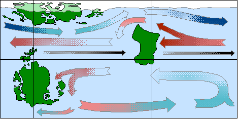
In the southern hemisphere, the bulk of Falah disrupts the currents. Warm tropical water arriving on the eastern seaboard of the continent pushes south towards the pole and then heads east back around the globe until it reaches Falah's western seaboard, where it turns north and once more flows westwards. This surface water circulation is a very effective heat exchange, and keeps the south pole ice-free. However, there is very little exchange of water or nutrients between shallow and deeper layers of the southern ocean.