Tilhekrhiste

Societal ties: Bartak
Current population: 1
Main language(s): Dam Bathtel
Area: 146,000km²
Natural and political borders
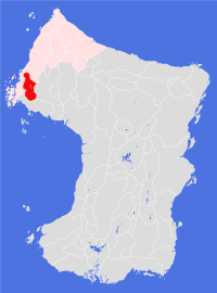
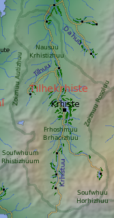
Clockwise from the north, the natural boundaries of the Land are the watersheds formed by Zoiznuu Rosoluu, Soufwhuu Horhizhuu, Soufwhuum Rhistizhuum and Zoiznuu Autizhuu.
Tilhekrhiste controls the river Tilhekrhistuu, and all its tributaries, south of 38.6°N
History
There was little Interest in the upper Tilhekrhistuu valleys during the Tells emigrations; not until the middle of the eighth century was any serious exploration of the Nausuu Krhistizhuu undertaken. Much of the impetus for this interest was due to the blocking of Damose activities in the lower valley following the war between that Land and the Land of Omne in gt712.
Much of this early exploration and exploitation was seasonal in nature: the Damose explorers had a good knowledge of the dangers associated with the Oute volcanoes, and chose not to risk their lives during the winter. The first permanent settlement was not established until gt770, and Krhiste settlement did not gain a permanent population until gt792.
All this changed in gt820, when explorers discovered extensive silver and copper deposits in the Frhoshmuu Bracizhuu, in the southernmost part of the valley. The discovery triggered a 'gold rush' mentality - it is estimated that more than 40,000 people arrived in search of their fortune over the course of the next five orbits. In the early part of the population explosion almost all goods and resources were imported, but within an orbit rampant inflation began to ravage the nascent local economy. By gt824 Krhiste had become a lawless place, beset by poverty and starvation - though even the worst rumours failed to stem the continued influx of fortune seekers.
Late in gt825 the inevitable happened, and disease - a form of airborne transmissible meningitis - broke out across the city. Damose had sent troops to the city and surrounding settlements in gt823 to try and control the general situation; now the army abandoned the valley to its fate. The Bartekol League finally intervened in gt826, sending a joint task force to bring some semblance of lawfulness to the mining settlements and to alleviate the worst of the human misery there.
For the next 30 orbits, the valleys became a special administrative area of the Bartekol League. Restrictions were placed on the numbers of people who could enter the area, a licencing regime introduced to control trade, new rules on the registration and ownership of minerals extracted - which specifically excluded personal ownership of land, and a basic system of rights and laws enforced. Much effort was put into establishing settlements near the main mining areas and developing a cultivation suitable to the area's unpredictable vagaries, though goats remains to this day a staple part of the the Land's cuisine.
For much of the special administration period, settlers had little input into the decision-making process. This changed in gt847 when the first elections were held to a national advisory council. The Land of Tilhekrhiste was finally established in gt850, when it joined the Bartekol League as its eleventh member.
During the gt960s the various political and physical battles west of the mountains between the Pentuuk and Bartak societies largely bypassed Tilhekrhiste. One direct consequence of the political manoeuvering was the establishment of a trading trail across the southern mountains to connect Tilhekrhiste and the Pentuuk Land of Horhe. Since the trail's opening there has been a slow but steady influx of Pentuuk settlers into the valleys.

Politics and economy
The Land operates as a centralised representative democracy, with a single body - the Council - responsible for legislative and executive decisions. The judiciary is independent of the Council, though some have questioned its apparent willingness to do the Council's bidding in recent orbits. Elected representatives currently have significant local decision-making powers delegated down to them, which can in turn be delegated to a favoured local group, company or temple. Critics of the system claim the arrangements often lead to nepotism and petty corruption.
If there is a Deity in Tilhekrhiste, it probably comes in the shape of money. The Land has its own currency - The Special Authority Trading Scrip - but the use of metal coins and bars for personal transactions is common: most locals know how to test a coin for its metal content.
Metals mining is the major source of wealth for most people - either directly or indirectly, and the prospecting and extraction of metals is the commonest form of employment. The willingness of the locals to eat goat meat, which are in plentiful supply in the valleys, means that agriculture is not as important here compared to most other Lands.
Culture and other issues of interest
Individual ownership of land and property is strictly barred. Instead, most people belong to partnerships which hold such resources in common ownership. Some of the largest partnerships are based on temples (which people have to buy into to join), but the majority of partnerships are based on the extended family. This gives the family (or clan) particular power in the social structure of the Land, and clans form the bedrock of Tilhekrhiste society.
The basic rules by which a family or clan partnership operates is determined by law, but there remains plenty of scope for partnerships to interpret these rules. A number of the most influential partnerships operate in a quasi-matrilineal fashion, and there is a general expectation that men move between partnerships more than women.
Surprisingly, perhaps, temples in Tilhekrhiste are not particularly religious - most temples are principally business vehicles. According to Tilhekrhiste custom, spirituality is a very personal and individual affair.
The 'national' alcoholic beverage is said to be fermented goat milk. It tends to be drunk on important occasions - birthdays, pair-bond ceremonies, deaths - though most people, given a choice, will drink imported alcohol before touching the local brew.
Key natural features
The Land occupies the upper valleys of the Tilhekrhistuu river, which originates in the Frhoshmuu Brhacizhuu and flows north through the Nausuu Krhistizhuu. The highest mountains are in the far south - Mt Horhuu reaches 3,380m above sea level; with the eastern mountains separating the Land from Cuskuu Bazizhuu being much lower. The western mountains are part of the active volcanic ridge, and thus considered far more dangerous. Krhiste Plantation covers much of what appears to be a dormant, but possibly not extinct, super-volcano caldera - the waters of Krhiste lake are warmer than would be expected for water at that lattitude and altitude, suggesting that thermal springs may lie in the bed of the lake.

Habitats
Even with the western mountains, enough storms make it into the high valley to give much of this Land a western coastal habitat, except in the far south where the mountains are higher. Here, a dry foothills habitat can be found, which in itself is an extension of the northern foothills habitat found in the easternmost parts of the Land.
Plantations and settlements
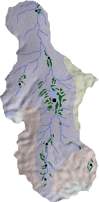
In addition to the Krhiste Plantation in the geographical centre of the Land there are seven settlements: two to the north in the Nausuu Krhistizhuu - the northernmost of which is on the verge of merging its cultivated area with the southernmost settlement in Damose; a settlement in the east in the Tilhuu river valley; three settlements south of Krhiste in the high valleys of the Krhistuu river valley; and a settlement in the far south east on the northern flank of Soufwhuu Horhizhuu.
Krhiste Plantation itself lies in a depression - possibly a caldera - through which the Krhistuu river flows; it almost completely surrounds a long lake at the northern end of this depression. The plantation is extensive, measuring some 90km by 70km at its widest points, and surprisingly productive, though soils in this area are more prone to local souring.
Key towns and cities
Rural population: 0 (0.0% of total)