Koletane
Societal ties: Bartak
Current population: 1
Main language(s): Varam Bathtel
Area: 183,000km²
Natural and political borders
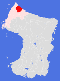
Koletane stretches along the northern coastline of the continent, claiming all land associated with the rivers that reach the sea between longitudes 161.3°E and 165.0°E - the Smikuu Tamalizhuu. All land that falls within the Gonanuu river system west of a point at longitude 160.3°E forms part of the Land of Aelhpaase.
Mountains mark the extreme reaches of the Land: Souvjarhuu Paasizhuu in the west, and the northern foothills of Zoiznuu Bathtelizhuu in the south.
History
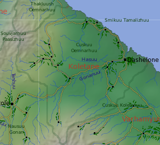
The first attempt to colonise the mainland appears to have been made by the prophet, Dasho, and his followers, who landed on the old coast near to present day Dashelone Plantation in gt384 or 385 (sources vary) and began the arduous task of cultivating the land from scratch. According to its own records, the settlement failed in the early gt420s following the death of the prophet, most probably from disease or in-fighting. The cultivation itself managed to become (marginally) self-sustaining - when pioneers arrived in the area to re-establish the settlement they found wheat and cabbage still growing in the old fields, and also small numbers of feral chickens. Dasho lives on in the name of the modern city and plantation.
The recolonisation of Dashelone was never part of the Tells Authority's plans. Instead, a small commercial venture sent pioneers out to the old plantation in gt475 to recultivate the area - a forerunner of the commercial colonisation of the Pentuuk Lands. Most settlers came from the northernmost Tells settlements, mainly young people sent by their families and communities. This colony prospered, though the company in Tells went bankrupt in gt498.
When the first pioneer teams from the Tells Authority arrived in Dhounaelhuu Varamuun in gt531 to begin large-scale cultivation, they were able to rely on the support and help of the Dashelone colonists. The early profits from this venture allowed the colonists to further develop their own plantation and begin work on new settlements across the Cuskuu Oemnarhuu.
In gt632 Dashelone Plantation, together with the settlements across the Oemnarh plains, agreed to formalise their political, legal and economic structures, founding the Land of Koletane - the second Bartak Land so created. The main driving force for this action was the growing influence and interference of the settlements further east in what local people considered to be local affairs.
Koletane was a founding member of the Bartekol League in gt720, and a key player in the political intrigues that plagued that organisation. The Land was the last to sign the New Agreement in gt751, as the people profited well from the tensions between the old executive and the members.
The Land had always been a representative democracy. A local economic downturn in the mid gt820s led to the formation of a new political movement which blamed the existing democratic structures for the depression. Catching the moment, the Koletane First party came to power in gt828 and effectively gave their leader dictatorial powers. During this time the Hasuu settlements in the east of the Land were developed.
The political situation led to the temporary expulsion of Koletane from the Bartekol League in gt837, when the regime violently supressed opposition demonstrations in Dashelone that spring. The expulsion was accompanied by a blockade of the city's port - most coastal trade at this time moved east to Defe. The economy crashed within months, and the regime were forced to hold elections in early gt838 - which they lost heavily. The blockade was lifted within days of the new government taking power, but Koletane was not readmitted to the League for a further 5 orbits.
In the gt860s the government of the day sought to expand the territory of the Land, funding a campaign in neighbouring Elimnarhe for the two Lands to join together. The reasons for this have never been fully explained, but were almost certainly to do with wider League politics. The initiative ultimately failed.
The city of Dashelone was severely damaged by a series of offshore earthquakes in gt1021. The most damaged parts of the city were abandoned, and remain ruined to this day. Immediately after the earthquakes there was a significant population shift to the inland settlements. The city has never fully recovered from these disasters, though the settlements continued to prosper and thrive.
Politics and economy
Since its earliest days, the settlements and city have operated as an representative democracy, both at the national and local level. Koletane has a single, separate judicial system which operates on the lines of interpreted law - different from most other Bartak Lands which prefer to use precedence as a guide for interpreting the law.
The economic base of the land is trade, and financial and personal services, though agriculture and manufacturing make an important contribution. In the early years, most goods traded between the east and west passed through Dashelone, and most of the ships that transported the goods were owned by Koletane interests - it was this apparent stranglehold on trade that led to the development of alternate trade routes across the mountains.
The Koletane currency has remained remarkably stable through the centuries, and is widely accepted throughout Bartak Society.
Koletane people have less aversion to the concept of the company as a business (and legal) entity than other Bartaks. Companies form the backbone of the economy - most people are employed by companies rather than by other people. Even neighbourhoods will organise themselves into a company if there is a profit to be made.
Culture and other issues of interest
The temples have little formal influence in local politics, and are mainly restricted (by law) to works of charity. Some temples are markedly evangelical in nature, and operate as franchises. The average Koletane can appear to be a little over-religious compared to the Bartak norm - the movement that led to the brief dictatorship in the 820s certainly started in the temples.
Even though money and religion may seem to be the driving force of Koletane society, the people themselves tend to be warm and generous to strangers; random acts of charity are often observed.
Koletane has been the birthplace of a number of notable artists and writers. There is a preference for individual artistic endeavour over that of the group. Competitive sport also plays an important part in people's lives, again with an individual emphasis.
Key natural features
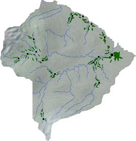
The predominant feature in the land is Cuskuu Oemnarhuu - named after one of the earliest Tells pioneer leaders, after whom the city of Ohmne and Land of Omne are also named. The plain is composed of low, undulating hills largely protected from the prevailing temperate winds by the bulk of the Paas mountains. A number of small rivers drain the coastal hills, but the main part of the plain is drained by the Gonanuu-Hasuu river system.
Habitats
Most of the habitat of Koletane is northern coastal. Northern valley and northern scrubland habitats are to be found in the eastern and southern corners of the Land.
Plantations and settlements
The northern coastal habitat has proved to be the easiest habitat to cultivate across the Bartak Lands, though it is not as productive as the western coastal habitat. Dashelone Plantation stretches some 100km along the lower reaches of the Gananuu river, and also snakes north, south and east along tributaries. The plantation supports two settlements in addition to the port city of Dashelone itself.
Four separate settlements can be found on the Smikuu Tamalizhuu, and a further settlement lies south of Dashelone. All have been long established. A settlement was also established midway between the cities of Dashelone and Tentole shortly after the Bartekol League came into existence.
The upper reaches of the river Hasuu support five settlements, and the cultivations of all bar the most northerly settlement have merged over time to form the Hasuu Plantation. These settlements were established in northern valley habitat around the gt820s and 830s, principally to relieve demographic pressure on Dashelone Plantation.
A new settlement - a mining community in the far south of the Land - was established in 1127.
Key towns and cities
Rural population: 0 (0.0% of total)